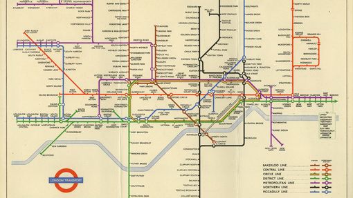
Map; pocket Underground map issued by UERL, 1908
Main details
| Reference number | 2002/264 |
|---|---|
| Description | This pocket Underground map shows the Railway lines belonging to the Underground Group in 1908. It includes the Hampstead Tube from Golders Green and Highgate to Charing Cross, The Bakerloo Tube extension to Paddington and the Great Northern Piccadilly & Brompton Railway branch to Strand, all of which opened in 1907. It also shows the Metropolitan Railway, which became part of London Transport in 1933. The sun burst motif, used on the front cover, was designed in 1907 by W J Pawsey. It is the earliest logo used by the Underground Group and marks the beginnings of co-ordinated marketing between all the Underground railways. The distinctive 'UNDERGROUND' lettering was introduced in 1908. The reverse lists interchange stations and provides information for travel to theatres, cemeteries, hospitals, hotels, restaurants and other places of interest. |
| Printer | |
| Dates | 1908 |
| Collection | |
| Object type |
|
| Location | |
| Topics | |
| Completeness | 76% |
-
Physical description
Dimensions Attribute Value Height 220mmWidth 272mmItem content Attribute Value Object title London Underground Electric RailwaysText HOW TO TRAVEL / IN AND AROUND LONDON -
People involved
Role Person(s) involved Printer Johnson, Riddle & Company Ltd, 1908Publisher Underground Electric Railways of London Co. Ltd, 1908
More about the development of Tube maps
London’s diagrammatic Underground map can truly be described as a design classic. See how the map has evolved from tracing the first railways in the Capital to encompassing an integrated network that covers ever growing distances.
Discover the history of one of the most famous elements of London's transport heritage - Harry Beck's Underground map.
Explore how London’s iconic Tube map has been used and adapted to celebrate the Capital’s history and people.


